Humans have impacted and transformed the high desert mountains, river valleys and buffalo plains of New Mexico for centuries, harvesting water for crops and shelter, celebrating life in ritual and ceremony, making landscapes sacred and special.
- Posts: 28 -
Rabbit Ear Mountain
Northeast Region: Clayton

Rabbit Ear Mountain is part of the iconic landscape visible from the Town of Clayton. The hills are remnants of volcanoes and part of the larger Raton-Clayton Volcanic Field. The mountain is named for the great Cheyenne Chief, Orejo de Conejos who was killed in a bloody battle with the Read more
Ralph Edwards Park
Southwest Region: Truth or Consequences
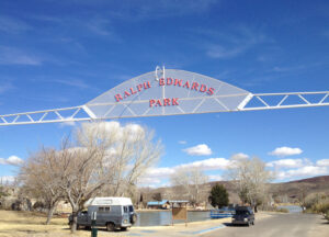
Constructed 1970. Ralph Edwards Park is located on Riverside between Cedar & Birch. Named for the host of the “Truth or Consequences” game show. The park entrance is just east of downtown, where Broadway, Austin and Cedar converge. The park offers shade trees, picnic tables, a gazebo, basketball courts, playground Read more
Rio Grande
Southwest Region: Truth or Consequences
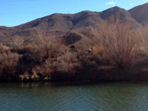
The Rio Grande is New Mexico’s longest flowing river, bisecting the state east and west and providing essential water to numerous communities between the Colorado and Texas borders. The river was harnessed by prehistoric Native American peoples and later Spanish Colonial settlers who redirected the waters through irrigation ditches called Read more
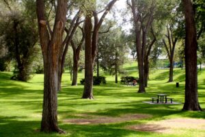
Riverwalk Park
West Region: Grants

Constructed 1990. The Riverwalk Park in downtown Grants is conveniently located next to historic Santa Fe Blvd., aka Route 66. The park offers many amenities for fun and recreation, including playground, fishing ponds, hiking and biking trails, and outdoor performing arts amphitheater and gazebo. 400 W. High St. Grants, NM Read more
Silver Hill Historic District
Central Region: Albuquerque
Constructed 1920. Silver Hill is a neighborhood in southeast Albuquerque which is significant as one of the oldest developments on the city’s east mesa. The neighborhood is roughly bounded by Central Avenue, Yale Boulevard, Central New Mexico Community College and the UNM campus. The early to mid-Twentieth Century neighborhood features Read more
Spring River Park
Southeast Region: Roswell

Constructed 1938. A prisoner of war camp was located in Orchard Park during World War II. The German POWs were put to work building infrastructure for the city. One of their projects concerned paving the banks of the North Spring River in stone. Some of the POWs worked together and Read more
Taos Acequia System
North Region: Taos

“The acequias of southern Colorado and New Mexico are the oldest water-management institutions in the United States of European origin. These irrigated agro-systems date to the time of Spanish settlement in the northern borderlands of Nueva Espana during the late 16th century with the Juan de Onate colony in 1598 Read more
Zuni River
West Region: Zuni

“The Zuni people have farmed the Zuni River Valley and many of its tributaries for thousands of years, raising primarily corn, squash, beans, and other vegetables. Many varieties of these plants are native to the Zuni Reservation.” – Pueblo of Zuni website According to Wikipedia, the Zuni River begin about Read more